Henniger Flats
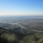


This justly-popular hike has a lot going for it, starting with spectacular views of Pasadena and downtown L.A. to the south and of our forested destination at the top. The Toll Road portion of it is a wide fire road, which allows us to easily walk and gab side by side. Finally, it has cushy amenities at the trailhead and top, including fun Nature Centers at both places (live, slithering creatures below, taxidermied specimens up above).
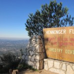
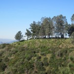
Henninger Flats was originally a “farm in the clouds” where Capt. William Henninger grew fruits and vegetables. In early 1900s, the land was leased to the Forest Service and first scientific reforestation experiments were conducted. Today Henninger Flats is home to the Los Angeles County Experimental Forestry Nursery, where the Los Angeles County Fire Department grows seedlings of pine, cypress, cedar, sequoia and other trees.
We’ll start out on an easy, flat route from the Eaton Canyon Nature Center, and then head far from the madding crowd up the steep Walnut Canyon horse trail. After a dozen switchbacks, the trail connects with the Mt. Wilson Toll Road, a not-quite-as-steep fire road that first opened in 1891 to haul telescope parts up to the summit of Mt. Wilson. At the top we’ll take a break to check out the shaded picnic areas, visitor center, pioneer museum, nursery, and clubhouse-like lookout structure. We’ll do a quick loop around Henninger Ridge before turning around to head back. On our way down, we’ll bypass the Walnut Canyon turnoff and walk down to the bridge (near the intersection to the popular Eaton Falls trail) and return to the parking lot via the Eaton Canyon Stream/Wash.
STATS
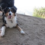
Level: ModerateGain: 1,400 feetDistance: About 6-1/2 milesTime: 3-to-3-1/2 hoursType: Combination single track and fire road; mostly out-and-back with a short loop on the return. Other than a few shaded stretches at the beginning and at the top, the trail is fully exposed to the sun.Trail Map: posted under the “More” tab at the top of the page, in “Files” within the drop-down menu.Dogs: Permitted on leashRestrooms: PortaPotties in parking lot (near yellow gate) before 9 am; restrooms in Eaton Canyon Nature Center after 9 am and at the Visitors Center at Henninger FlatsWater: Available at Eaton Canyon Nature Center and at the Visitor’s Center at Henninger Flats.Parking: Free lot on site. It’s a popular destination, so if the lot is full, there’s usually overflow parking at the adjacent equestrian center or on the street on Altadena Drive.Bring: Cameras, plenty of water, sunscreen, a hat, and some snacks to share at the topOther: Eaton Canyon Natural Area has a beefy website detailing its many special events, meetings, guest speakers, guided walks, docent training and volunteer opportunities. The Nature Center off the parking lot has some interesting historical displays (including news coverage of the 1993 fire), lotsa live snakes and nice gift shop.
DIRECTIONS
Eaton Canyon is located at 1750 North Altadena Drive, one block north of New York Drive in Pasadena, California. There’s a sign on the east side of the street which clearly marks the entrance to the Park.
From the 210 Freeway eastbound, exit at Sierra Madre Boulevard/Altadena Drive. Turn left (north) at the first light (Altadena Drive) and go 1.6 miles to the park entrance.
From the 210 Freeway westbound, exit at San Gabriel Boulevard/San Marino. Turn right (north) at the second light (Altadena Drive) and go 1.5 miles to the park entrance.
Categorised as: Uncategorized
Leave a Reply
You must be logged in to post a comment.